
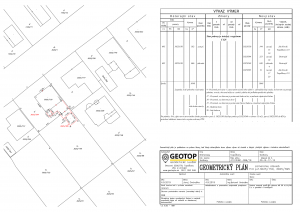
What is a geometric plan?
The geometric plan is the technical basis for legal acts, public documents and other documents which, according to the law, certify real estate rights, including lease agreements, and may also be used to record a change in the CN database.
For what purposes is a geometric plan made?
The geometric plan shall be drawn up in particular for the purposes of:
(a) division of immovable property e.g. subdivision into building plots, division of the garden …
b) adjustment of the real estate boundary e.g. change in the course of the ownership border between neighbors …
c) determination of property rights to real estate e.g. determination of ownership of land that does not have a certificate of ownership in the current operation …
(d) restoration of the boundaries of the original parcels or parts thereof e.g. separation of the original land from the agricultural cooperative …
e) focus of the construction on issuing a building permit focus on new house, garage …
f) focus of the construction under construction e.g. focus of the construction on providing credit … (g) mergers of immovable property e.g. merging several plots into larger units …
h) granting of rights to a part of real estate – marking of easement e.g. the right to cross the land …
What is the demarcation of a building?
The delineation of the building object is actually a marking of the spatial position of the building object in the field on the basis of the supplied project documentation. We usually outline the perimeter masonry of the building on the 1st floor, or the perimeter of the foundations. The marking of the spatial position is mostly done with iron roxors, but it is not a problem to mark the building directly on the building benches. The height of the building will be made by marking the building 0.00 resp. height dimension according to the customer’s request, e.g. on a wooden peg.

What do I need to delineate a building?
For the processing of the demarcation drawing and thus also for the demarcation itself, it is necessary to document the approved project documentation in written or in electronic form. If the documentation contains a layout drawing with coordinates in the state coordinate system S-JTSK, this will also suffice. To calculate the coordinates of a building we need: Installation of the object within the land – situation of settlement (this information is also part of the building permit) Floor plan of the 1st floor of the building (foundations)

![]()
What is the demarcation of land?
Demarcation of the boundary of the land means the transfer of the position and size of the plot registered in the cadastral map to the terrain. The delineation will be performed on the basis of the Real Estate Cadastre documents: cadastral map, GP, lists of coordinates, sketches of original measurements, etc.

What is the result of the demarcation of the land boundary?
The result of the demarcation of the land boundary is the marked boundary of the plot in the terrain (wooden pegs, metal pipes, roxorms …) and a demarcation protocol verified by an authorized surveyor and cartographer. The processed documentation contains the Protocol on the demarcation of the land boundary and a graphic representation – a demarcation sketch.

What is the documentation of the post-implementation focus of construction objects?
Documentation of the post-implementation focus of buildings is geodetic documentation showing the location and course of newly built buildings (construction, utilities …). The processing of documentation is preceded by the geodetic survey of individual buildings. The aiming is performed in the state coordinate system S-JTSK and the altitude system Bpv.

When do I need to prepare documentation of the post-implementation focus?
I need to prepare documentation of the post-implementation focus for approval. The building authority usually requires a geometric plan for approval – a drawing of the new building in the cadastral map and a geodetic post-implementation survey of IS connections (the focus is also part of the drawing in the digital technical map of the city).

What is an address point?
The address point is the position of the entrance to the building expressed by spatial coordinates. It is prepared mainly for the address register, which is a source of information on addresses, for the needs of public administration, for rescue and security forces (rescue system, fire brigade, police) …

How is the address point measured?
When focusing the building for approval, we will also focus on the location of the main entrance to the building (apartment building, family house, garage, non-residential buildings …), ie the left and right edge of the entrance and the height of the floor at the entrance. From the measured data we make an elaboration, which has two parts.
Graphic part – the position of the focused building in the plot with the marking of the address point with a red cross
A written part in the form of a table, which contains the ellipsoidal coordinates of the address point, the designation of the region, district, municipality in which the building is located and the name of the surveyor who surveyed the address point.

Focus of profiles and cubatures
What are profiles?
When designing or orienting
the design, the actual state of the
line structures, the elevation ratios
of the terrain can be determined by
means of vertical profiles. The
profile is a section of a vertical
plane with the terrain along the
selected line.

Profile measurement
The longitudinal profile of the line structure is measured over selected points – the route axis (route points, points in the selected station, hectometer …) using leveling (trigonometrically) with connection to the points of the ŠNS, or PPBP.

How to proceed with the property settlement of real estate?
If you are the owner of land that is registered on the title deed in the E-CN register of the Real Estate Cadastre (legal parcels or so-called parcels of the designated opera), you own these lands, but usually can not use them, because the use applies to land registered in the C-CN register of the Real Estate Cadastre. The same applies if you want to build a building on such land.

In such a case, it is necessary to prepare a geometric plan for determining ownership rights to real estate (for property settlement of real estate), which the owner, together with ownership deeds confirming ownership of the original real estate, or with sales contracts, submits for registration in the real estate cadastre.

What are the works in the field of engineering surveying?
Engineering geodesy deals with tasks in construction, whether in the creation of materials for design activities, demarcation work, post-implementation focus and elaboration of documentation, control measurements during construction, measurement of displacements and deformations of buildings…

From the mentioned works we prepare and provide authorization activity in the mentioned area especially in:
– demarcation of buildings
– processing of documentation of post
-implementation focus of construction objects
– processing of measurement and drawing into a digital technical map of cities
– focusing and processing of topographic and elevation plans
– creation of purpose maps and plans
– measurement of profiles and cubatures

